
A comprehensive and easy-to-use guide to climate classification. Just two numbers, the temperature and precipitation zones of a single location—preferably your own to start—serve as a reference point to most of the system. The new standards can be easily applied to many topics:
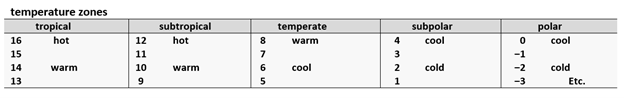
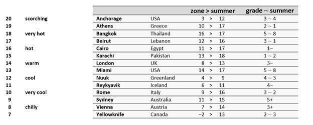
- Since only a handful of zone 17 climates have been found, these are included in the hot tropical category.
- The polar climates continue to zone ‒18 and can also be divided into groups of 4. Not counting research stations in locations which are otherwise uninhabited, at zone ‒10 Verkhoyansk Russia has one of the coldest winters on the planet.
- Alternate names are possible: warm subtropical or hot temperate; warm temperate or cool subtropical; cool subpolar or cold temperate, etc.
seasons
The system of zones and grades can be used to define differences by seasons, months, weeks—all the way down to a single day in the case of the temperature zones.
In some climates the summer is wetter than the grade while in others it is equal (that is, when rounded off to the higher number) or lower than the grade. The symbol – is used when the rounded off grades are equal, but the summer is in fact drier (for example, 3–); + when it is wetter. No symbol is necessary when the difference is very minor.
summer
aridity index
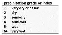
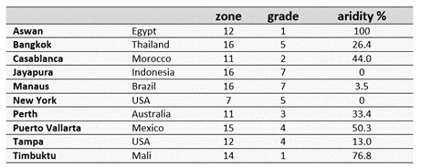
How dry is dry? The humidity grades can also be converted to define total annual dryness as a percentage called the aridity index. This figure adds greatly to our visualization of a particular climate and the transition of climates from one region to the next. 100% is equal to a desert with extremely little or no (measurable) precipitation at all. Desert climates begin at 66.6%. How close is your climate to a desert climate–to 66.6%?
aridity and the dry season
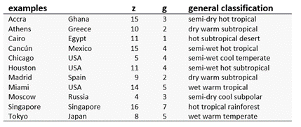
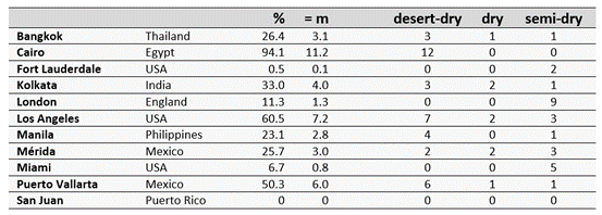
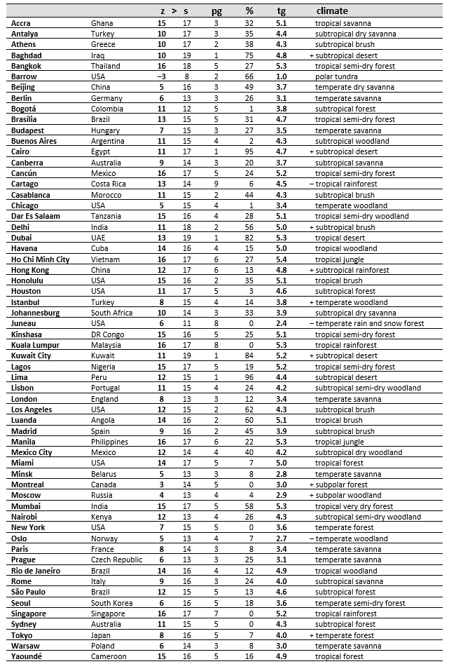
The aridity index as converted to a “monthly-like” total (m) sometimes matches or resembles the length of the dry season. For example, Puerto Vallarta is 50.3% arid and likewise has a desert-dry season which lasts 6 months of the year (50% of the year). In other cases, however, the aridity is spread out over many months or even the whole year. In such cases the “monthly-like” total is simply the total aridity as if it were compressed when measured according to months in a year. For example, London is 11.3% arid = 1.3 months/year, although its aridity is actually spread out over the course of 9 (semi-dry) months.
defining seasons by zones
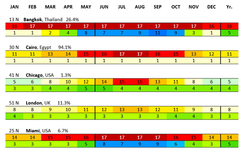
The zones sharply distinguish the wet and dry seasons or hot and cold seasons and detail the main differences within the seasons. For example, Bangkok has a wet season lasting 7 months, 6 months of which constitute a rainy season; the remaining 5-month long dry season includes 3 months of desert-dry weather. Miami also has a 5 month long dry season, but the numbers reveal that this season is specifically semi-dry, with moderate aridity in total—6.7% as opposed to Bangkok at 26.4%. Chicago has 4 months in the tropical range, that is, 2 months of hot summer and 2 months with mild summer temperatures. London has 2 “warm tropical months” or in other words a short mild summer.
ecological grades
The precipitation grade and aridity index allow us to identify the ecological grades, although the actual or historical ecosystem is dependent on many other factors. Together with the temperature zones we have a general description of a climate.
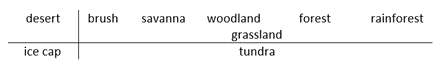
The ice cap (cold desert) and tundra are determined by summer temperatures and are not fundamentally altered by their precipitation grade or aridity index.
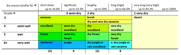
- The dry and very dry savanna are conveniently located in the brush rectangle. The very dry savanna begins at 50.1% like the other very dry climates.
- A designation such as “dry forest” refers to a seasonally dry forest or a forest with a lengthy dry season. Hence, it is not a forest with less precipitation on average, but a forest with more precipitation on average, except that this precipitation is more heavily concentrated seasonally. Not all “decidedly seasonal” climates, for example, Bizerte Tunisia shown below, result in an alteration of the name of the grade.

- The transition from the brushland to the desert occurs at 66.6%. In some cases, however, the desert aridity crosses into the brushland grade, and vice versa, sometimes the brushland precipitation crosses into the desert grade.
warmth index
Also called the temperature grade (tg), it is the sum total of average yearly “warmth” or temperatures above freezing—a measurement of seasonality as such. In borderline situations the name of the temperature zone provides the name of the climate. For example, Canberra Australia has a warmth index of 3.7 which could be construed as either temperate or subtropical. However, since it is in a subtropical zone (9) its climate will be identified as subtropical rather than temperate.

The minus sign (‒) is used when the temperature grade (tropical , subtropical, etc.) is lower than the range indicated by the zone (tropical, subtropical, etc.). For example, Cartago Costa Rica is in a tropical zone (13), but the cooling effects of its high altitude—4710’ above sea level—results in a milder version of a tropical climate. This can be seen once its seasonality or warmth index is taken into account, 4.5, a subtropical grade, hence, ‒tropical.
Kuwait City is in a subtropical zone (11) but has a warmth index typical of a tropical climate, hence, +subtropical. This is not surprising because Kuwait City has a desert climate with a scorching hot season. In contrast, Houston Texas, also in zone 11 but not nearly as hot seasonally considered, remains in the subtropical grade.
- A few locations are two ranges warmer (‡, used as a double plus sign) or two ranges cooler (=, intended as a double minus sign, not an equal sign).
Buy now for your guide to several thousand locations worldwide and a comparison of other classification models—the USDA cold-hardiness zones, Koppen climate classification, and Holdridge life zones.